Tag: crime | Atom Feed
 |
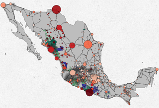
| Click on the image to go to the interactive map |
The Mexican government recently released crime data for 2011 at the municipality level. Sadly, it is no disaggregated by month, but beggars can’t be choosers. To analyze the data I made an interactive map with d3 that includes the locations of the municipalities with the highest drug plant eradication and a 2d kernel density estimate of the location of meth labs based on newspaper reports.
Unless otherwise stated, the content of this page is licensed under the Creative Commons Attribution 3.0 License, and code samples are licensed under the Apache 2.0 License. Privacy policy
Disclaimer: This website is not affiliated with any of the organizations or institutions to which Diego Valle-Jones belongs. All opinions are my own.
Special Projects:
- Mexico Crime Rates - ElCri.men: Monthly Crime Report for all of Mexico
- Mexico City Crime - HoyoDeCrimen.com: Geospatial crime map of Mexico City
- Mexico City Air Quality - HoyoDeSmog
Blogs I like:
